When It Rains It Pours into Hitchcock Woods
The Hitchcock Woods Foundation Board of Trustees has unanimously pinpointed stormwater runoff from the City of Aiken to be the greatest threat to Hitchcock Woods.
What is stormwater runoff?
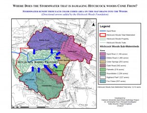
Stormwater runoff is generated when rain falls on hard paved surfaces (such as streets and parking lots) and does not soak into the ground. Stormwater runoff from over 3,800 acres of property (within the City of Aiken municipal limits) drains into Hitchcock Woods, causing extraordinary damage and erosion to this state and national treasure.
The Hitchcock Woods Foundation unanimously identified the unmanaged stormwater runoff from the city as the single greatest threat to the Woods.
Why is stormwater runoff harmful to the woods?
Stormwater runoff picks up trash, pollutants, dirt, grime, fertilizers, oils, pet feces, insects and dead rodents on city streets and flushes them directly into Hitchcock Woods without treatment of any kind. Large quantities of fast moving stormwater runoff washes away land and carries silt downstream that fills in and destroys wetlands. One rain discharged 35 million gallons of untreated stormwater runoff into the Woods over a 9 hour period and at a rate of 100,000 gallons per minute at its peak!
Damage to the woods caused by city stormwater includes:
- Massive Erosion: Woods trees and land are destroyed or washed away after every rain.
- Sedimentation: Silt and sediment from large scale erosion travels downstream, smothering and killing bottomland hardwood trees and filling in and destroying wetlands.
- Pollutants: Stormwater runoff is a leading source of water pollution nationwide. City stormwater runoff picks up and flushes, trash, chemicals, sediment and bacteria into the Woods that is harmful to its ecological health and pristine beauty.
For a comprehensive list of damages to the Woods caused by City stormwater runoff since 1950, click here
City adopts historic stormwater plan
In January 2018, after twenty years of studies, the City adopted Phase I of a long term plan to address the destructive runoff from the downtown area into the Woods. The approval came almost a year and a half after the mayor initiated the Stormwater Task Force comprised of representatives of the Hitchcock Woods Foundation, citizen stakeholders, and city representatives. The task force selected the engineering firm of McCormick Taylor out of Columbia to serve as its technical stormwater consultant. The task force was also advised by Clemson University, who assisted in the collection and verification of data from various locations in the downtown watershed.
“The plan developed by McCormick Taylor and endorsed unanimously by the task force is a giant step towards an achievable solution,” says Pat Corey, Chairman of the Board of Trustees of the Hitchcock Woods Foundation. “The approved plan is a common sense, cost-effective solution that can be implemented over time, allowing the city and the foundation to garner additional financial and technical resources through grant opportunities. The foundation is deeply grateful for the city’s commitment to stop the destruction of the Woods after all this time.”
The long-term plan involves the construction of a variety of widely-used and proven BMPs (Best Management Practices) in strategic places and the ultimate restoration of the Sand River channel. Attractive and practical dry detention beds will be constructed on certain parkways with the appropriate hydraulic properties; existing detention ponds in certain areas may be upgraded and expanded; and underground detention facilities will be built on Hitchcock Woods property.
How can you help protect and preserve Hitchcock Woods for future generations?
Proper stormwater collection and discharge is the City’s responsibility for all of its citizens. A proper, modern stormwater system that meets federal and state standards must be a priority to protect and preserve Hitchcock Woods for our children and grandchildren. You can stay informed and voice your support of the city’s actions to address this issue. You can also get involved by attending city council meetings and writing to local papers. Visit https://www.cityofaikensc.gov/government/city-council/ and https:/www.aikencountysc.gov/SGovernment.
Stormwater in the news
Browse the latest news releases and press coverage
To read the letter from Patricia E. Corey Hitchcock Woods Foundation Chairman, that was distributed at the January 8th Aiken City Council Meeting, click here.
For more information about stormwater and actions you can implement on your own property to help reduce stormwater runoff off and pollution, click here.
Damage to the woods caused by city stormwater since 1950:
- Barton’s Pond dam – washed out two times, loss of pond
- Robinson’s Pond dam (Kalmia Lake) – washed out, loss of pond at Tea Cottage
- Bridge over Calico Creek at Coker Springs Road washed out two times
- Other sand bridges, i.e. Doll Lane washed out. Replaced by city (Sewer line?)
- Whitney Drive from Nursery Field to Fox Field is now washed out and impassable
- Lover’s Lane from Show Grounds to Barton’s Pond (roadbed of the historic Charleston to Hamburg railway) washed out and impassable
- Showgrounds have been inundated with sand two times. The first time the ring and house had to be moved. Aiken fences were torn down and not replaced.
- Bear Pit Line to Sand River washed out. Required construction of another path to the County Road.
- Grand Canyon of Sand River formed (once passable by foot, now 70 feet high and 200 feet wide)
- Creek at Swampy Cut difficult to cross, bride was constructed.
- Fox chase detention pond – spreads sand onto Woods property, plastic “riprap” unsightly.
- Grand Canyon emerging at Dibble Road (25 feet at highest point at present)
- Cathedral Aisle bridges undercutting a constant problem.
- Berrie Road entrance constantly eroded.
- Pollution, both chemical and litter from surface run-off.
- Loss of habitat for native plants and animals with negative impact on the ecological health of the Woods.
- Negative impact of siltation (filling in) on the wetlands.
- Barton’s Pond wetland trees dead and dying from sedimentation and smothering.
- Coker Springs Entrance and Canyon emergence (10 to 15 feet high at present)
- Dibble Road Entrance area canyon has grown to 25 feet high and wide.
- Clark entrance and outfall area severely eroded.


